

The Insitu ScanEagle prepares to launch over the Paradise Fire in Olympic National Park in Washington state earlier this year. Insitu Photo
The integration of unmanned aerial vehicles (UAVs) into the Department of the Interior’s (DoI’s) wildfire fighting arsenal took a large step forward this summer, as trials began in their use beyond line of sight on active fires.
At the Aerial Firefighting Safety Forum in November, Mark Bathrick, the DoI’s director of aviation services, said the department plans to fully implement UAVs into firefighting operations in three to five years, and highlighted how this technology could be used to save time, money, lives and resources.
Currently, aircraft assets help fight fires during daylight visual flight rules conditions. Bathrick argues adding UAVs to the mix will allow aircraft to fly 24/7, providing coverage at night and during instrument flight rules conditions in the daytime.
The DoI began examining small UAV (sUAV) use in 2006, and has worked closely and collaboratively with the Federal Aviation Administration (FAA) and other agencies and contractors to gradually develop their UAV program. This culminated earlier this year with the FAA’s approval of beyond line of sight operations in DoI temporary flight restrictions (TFRs) around fires. After nine years of planning, the first authorized UAVs flew during an active fire.
The DoI chose three sUAV models to be demonstrated during fires, all at the cost of the manufacturers — the Insitu Scaneagle, Textron Aerosonde Mark 4.7, and the Lockheed Martin Stalker XE.

The Scaneagle was one of two small unmanned aerial vehicles demonstrated on active fires this summer. DoI Photo
The Scaneagle and the Mark 4.7 were demonstrated on the Paradise Fire in Olympic National Park and the Tepee Springs Fire in the Payette National Forest in Western Idaho. For both demonstrations, altitude restrictions were placed for the unmanned aircraft (typically well above manned operations), as well as geofencing to assure separation from manned aircraft and to keep the UAVs from flying over private land.
“We are very sensitive to safety and privacy,” Bathrick said of the extra step to avoid private land flyovers. “That was important on the Paradise Fire, which was close to private land. We could look at the fire if it entered private land, but we wouldn’t fly over private property.”
Bathrick said the demonstrations proved very successful.
“In both fires, we operated in our TFR, coordinated with local aircraft operators, and found it easy to segregate airspace for safety,” Bathrick said. “It was very controlled and we did not have a single incident or close call.”
Between the two operations, UAVs flew a total of 58 hours and 10 days. They were operated beyond line of sight, providing real time intelligence, surveillance and reconnaissance, streaming video and infrared data live via satellite to the web. The information firefighters received from the aircraft was eye-opening.
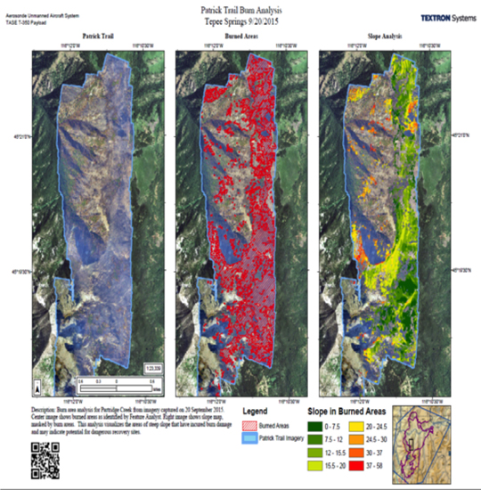
The image analysis provided by UAVs following the Tepee Springs Fire in Western Idaho. The center image shows the burned areas, and the right image shows a slop map, marked by burn areas.
“The streaming mid-wave infrared views provided clear images through the smoke to hot spots and our water drops,” Bathrick said. “In a water drop, you want to hit the edge of the fire. The images we received showed the helicopters were dropping on the fire, which with all the smoke the pilot thought was the edge. With the drone, we were able to provide information to the pilots to assist with accuracy. Not only that, we were able to see, in real time, the effectiveness of our drops from 13,000 feet. Since the first water drop in 1930, we’ve never been able to analyze the effectiveness of our efforts. We can do so much to better our techniques and be more efficient with this information.”
Additionally, the UAVs provided 3D mapping of the fire area and analysis of erosion-prone post-fire areas that will help other agencies target potential landslide zones for replanting or road protection.
The UAVs also demonstrated wildlife surveys using infrared technology, seeking out elk around the fire zone. “We were looking for where the wildlife had run to, but the infrared images of the elk showed us we could easily use this technology to track our firefighters in real time on the ground. Firefighters know while the fire may be out, a spot can still be hot. We can see that with the drone and target those areas, directing firefighters away from danger or toward hot spots that needed attention.”

This infrared image shows the position of elk (the bright spots in the center) around the edge of a fire zone. DoI Image
While the demonstrations provided a great deal of information, Bathrick said there are still area that require further development.
“We learned the drone companies didn’t fully understand how we operate and what kinds of backend data and information we want to gather and put in the hands of our firefighters,” he said. “For instance, we don’t just want the image. We want the geo-rectified image — where is that image on the map?”
Other challenges included backend data management for rapidly creating mapping products and automatic sensor adjustments during mapping.
To address all of these issues, Bathrick continues to work on educating the UAV industry on DoI needs. Meanwhile, the department hopes to demonstrate more drone operations in the 2016 fire season. The plan is to work closely with the FAA to pave the way for drone operations on every fire and to open bids for UAV contractors to provide those services, just as the department currently does for manned aircraft, within the next few years.