Beginning in early November and lasting for several months, a low-level helicopter will begin flying over parts of seven states in the Mississippi Alluvial Plain, or MAP, to acquire a more robust picture of aquifers in the area.

This high-resolution, airborne geophysical survey, coordinated by U.S. Geological Survey scientists in partnership with local agencies, will provide critical data for the evaluation and management of groundwater resources in the region. This survey represents the second phase of the study as initial flights and data acquisition over the MAP started in February using the same helicopter system.
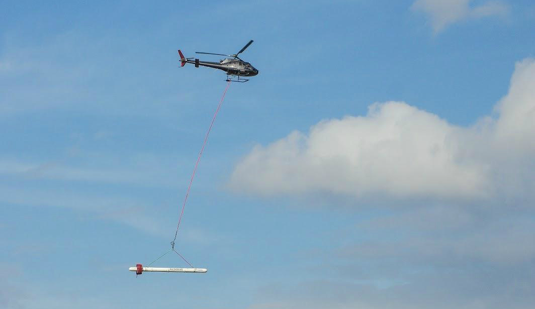
The helicopter and geophysical instrumentation is expected to arrive in Greenwood, Mississippi, on or around Oct. 31. After arrival, setup and testing will occur, so the helicopter and device it tows beneath will be visible as soon as Nov. 2 to 4. Once testing is completed, daily production flights in the region will begin, with flights operating out of Greenwood for approximately two weeks.
CGG Airborne of Ontario, under contract to the USGS, will make the daytime, low-level flights over more than 20 million acres within the MAP, including a buffer around the entire area. Experienced pilots who are specially trained and approved for low-level flying will operate the aircraft. All flights are coordinated with the Federal Aviation Administration to ensure accordance with U.S. law.
The MAP is one of the most productive agricultural regions in the nation and depends on groundwater for irrigation. It constitutes the third largest area of irrigated cropland in the U.S., consisting of approximately 29,000 square miles, or 19 million acres, and includes parts of Missouri, Tennessee, Arkansas, Mississippi, Louisiana, Kentucky and Illinois.
“This survey will allow the USGS to develop a high-resolution, three-dimensional representation of the groundwater resources for one the most important irrigated agricultural regions in the U.S.,” said project lead and USGS scientist Wade H. Kress.
Instruments on the helicopter will collect information about the geology in shallow aquifers of the region. When the data analysis is complete, resulting state-of-the-art maps will help USGS researchers understand the aquifer system that supports groundwater resources at depths up to about 300 feet underground.
This survey will be flown along mainly east-west lines at about 200 feet above the ground. The helicopter will have an attached electromagnetic instrument housed in a cylinder called a bird that is towed about 100 feet beneath the aircraft.
The helicopter will also carry scientific instruments including a magnetometer and a gamma-ray spectrometer. None of the instruments pose a health risk to people or animals.
The survey is being conducted by the USGS Water Availability and Use Program as part of the Mississippi Alluvial Plain Regional Water Availability Study.