

Variation is a big part of any utility pilot’s everyday routine. However, once in a while a mission comes along that provides a completely different experience to any you’ve had before. I was fortunate enough to be slated for one such assignment earlier this year, when I flew researchers conducting seal counts in the Arctic.
The expedition was run by the Institute of Marine Research (IMR), based in Norway. They count seals about every five years to track the general population from a sustainability aspect.
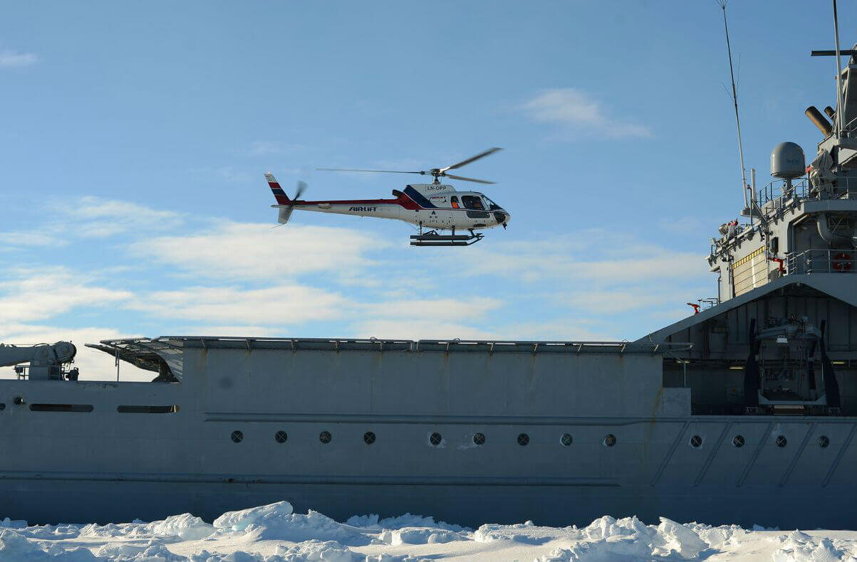
Using an Airbus AS350 operated by Airlift, the company I work for, our mission would be to fly reconnaissance flights in the West Ice in the Greenland Sea to locate patches of baby harp and hooded seals. Once we’d located the patch or patches, we’d set GPS beacons for aerial fixed-wing assets to take photos that would enable later counting of the pups. The third objective would be to fly staging flights to determine the age of the pups in the patch. So: find the seals, mark the area, then staging.
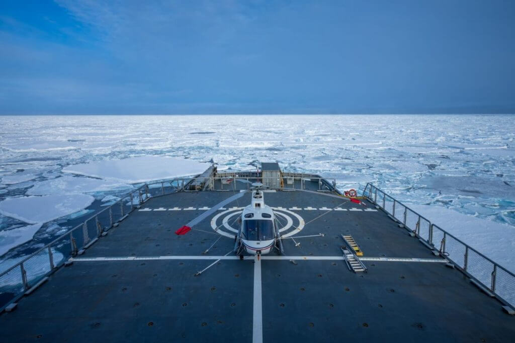
East of Greenland and north of Iceland, the West Ice is covered in pack ice in winter. But given that we would be flying there in mid-March, there was a lot of uncertainty as to how close to Greenland we would have to get to find the ice. We decided to aim for an area along the 72˚30N parallel and follow that into the ice a little bit to escape some of the swells from the Greenland Sea that could make operating from a ship impossible. A dedicated research vessel was not available this time around, but luckily the Norwegian Coast Guard icebreaker KV Svalbard stepped in and filled that role.
The Norwegian Coast Guard is a branch of the Royal Norwegian Navy, so before we set out, I needed to brush up on naval ops procedures. I then planned our more-than 600-nautical-mile transit from our base in Førde to the rendezvous with the vessel in Tromsø, and completed some general and mission-specific risk analyses.
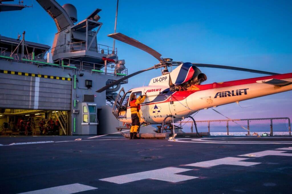
After joining the vessel in Tromsø, we removed the helicopter’s blades and wheeled it into the hangar. We were forecast rough conditions for our transit, so we lashed down the helicopter and ensured it was securely fastened.
The transit took three days each way, which meant we only got six days in the mission area. That is a pretty small window in the best of conditions, so we were really at the mercy of the weather. The three main parties onboard — the Coast Guard, the expedition, and us as the air asset — held daily briefings to thoroughly plan and prepare to ensure we made the most of our time in the West Ice.
Our greatest concern was having to land on ice and waiting for the vessel to reach us, either due to a technical issue or a sudden change in weather. We identified the latter as more likely, so much of our effort went into preparing for that eventuality. We can’t affect the weather, but we can adapt to it. We decided the weather and weather trends would be the main limiting factors as to how far away from the vessel we would dare venture.
I figured if we had to do a landing due to poor weather, the lighting conditions would be conducive to a whiteout and possible rollover on landing (not all ice floes are flat). That would make an already bad scenario potentially deadly. I was able to get my hands on some canisters of orange smoke that we could toss out for a reference if I needed one.
In case a rescue was necessary, close flight following with the vessel was essential. Satellite tracking on our aircraft was to be an incredibly valuable resource that gave us all peace of mind. The vessel could track us via a webpage as long as they had VSAT coverage. If they lost coverage, they would call air traffic control (ATC) in Longyearbyen. This way, we had a robust flight following system even when we were beyond the vessel’s radar coverage. Considering we were operating at about 400 feet, that coverage was lost fairly quickly.
Safety briefings touched on emergency and survival equipment, as well as covering basic helicopter safety issues. We placed our special arctic survival kit and standard survival kits different side holds, so we would have access to at least one burner — even if the helicopter were to roll to one side in a crash. We briefed using the dinghy, and discussed how that could be used as shelter on the ice if need be.
Taking flight
We reached the close drift-ice late in the afternoon on the third day. To be able to begin operations as early as possible the following day, we needed to get far enough into the ice to escape the swells before nightfall. Running in ice is very noisy, so to ensure we all got the rest we needed, we decided not to run in ice at night during the expedition.
Walking onto the bridge the next morning, we saw clear skies. We had two sorties planned for the first day, and the first of these was an exercise with the vessel to ensure all procedures were established.

Naval ops are quite different to how we normally operate. Radio procedures and hand signals need to be adhered to, as well as the “Ship-Helicopter Operating Limits” (SHOLs). SHOLs are specific envelopes for the various operations on the flight deck. They cover everything from traversing the helicopter to the different takeoff and landing procedures. Each operation has pitch, roll, heave, and wind velocity limits. The wind velocity differs a lot for the various flight procedures.
We had fore-and-aft port side takeoff/landings as our preferred procedure. This required the wind to be in the sector primarily just left of midship for us to be given a green deck. This procedure had us lifting up facing forward, then moving sideward to the left until we were clear of the deck, then turning away from the vessel and accelerating. Landings followed the same pattern.
We did some deck landing practice (DLP) and performed a “crash on deck” exercise, and took a break for lunch before returning for the afternoon flights.
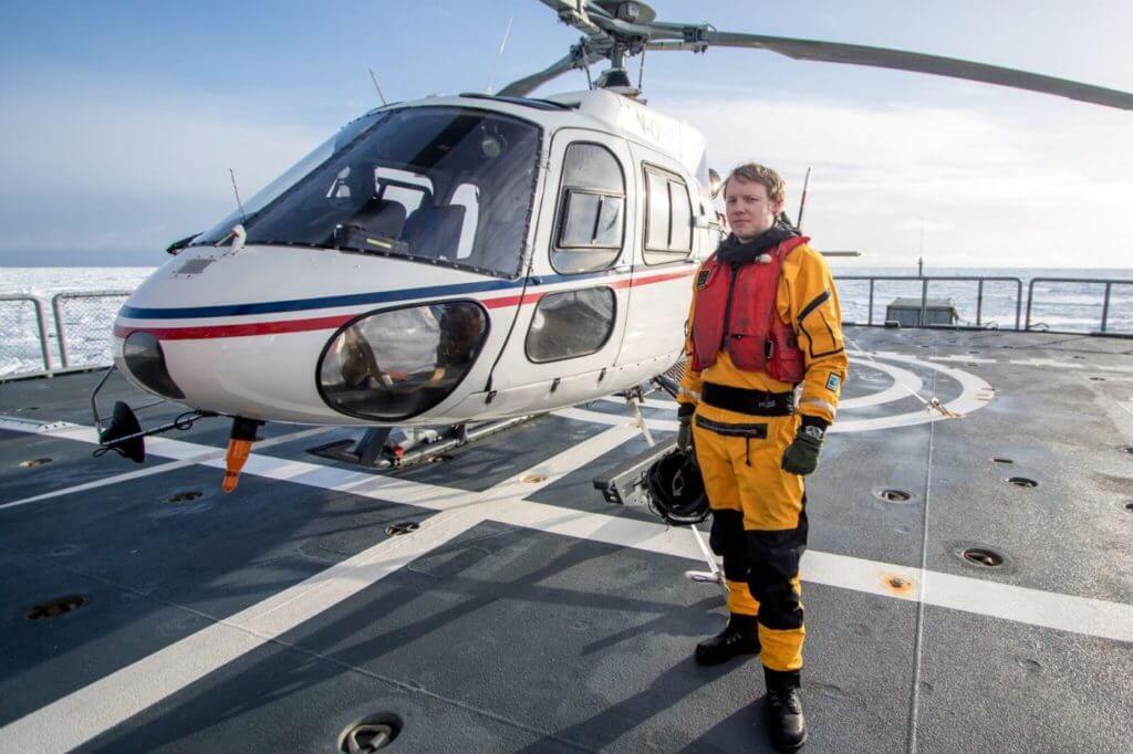
We took three researchers on each flight, rotating them between sorties. This load gave us maximum range — a playtime of about two and a half hours, with a 30-minute reserve.
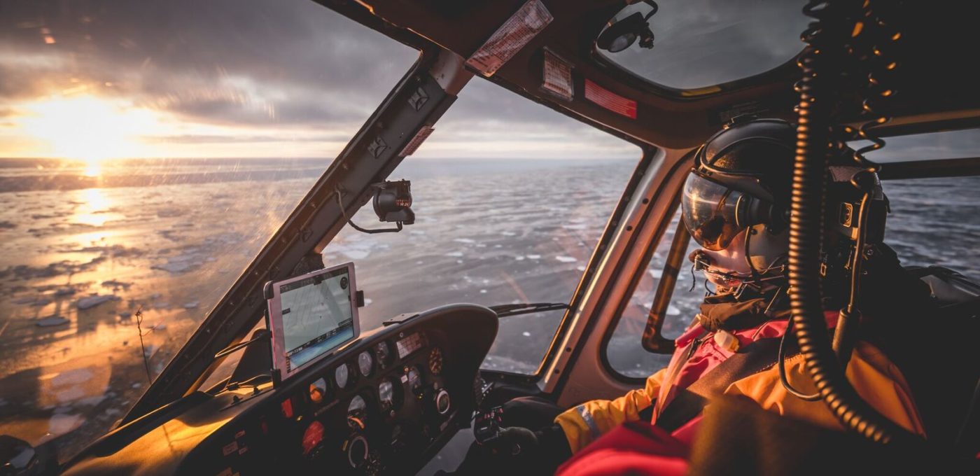
For the recon part of the mission, the researchers acted as spotters, trying to find what proved to be increasingly elusive patches of seals. We flew east-west transects spaced five nautical miles apart. They stretched from the edge of the drift ice and westwards, sometimes as long as 50 nautical miles. Due to the large magnetic variation in the area, we used the GPS and flew true tracks along each five-minute parallel, as long as we were flying over suitable ice for the seals.
We reported “pps normal” to the vessel every 20 minutes. When we lost radio coverage, which wasn’t unusual, we called them using the satcom. As long as they had our GPS tracking working we omitted position reports, and instead just reported endurance and any intentions to deviate from our predictable pattern.
Day one left us having seen five polar bears, but very few seals.
On the second and third day, a low ceiling in our southernmost search area made us unable to reach the easternmost areas, but we were still able to cover a lot of ground. It was in this overcast area we found our first patch of hoods. This find was deemed important enough to part ways with one of our five GPS markers. As I had anticipated in our risk assessment, landing on an ice flow in flat light would prove to be challenging. We notified the vessel, tossed out a canister of orange smoke, and landed using that as a reference.
As much as the photographer in me would have liked to shut down on an ice floe to take some pictures, the risk versus reward didn’t justify it. The researchers only required about five minutes to place the marker, and not being able to start again on an ice floe 50 nautical miles away from the vessel was not something I wanted to risk. Instead we kept an eye out for polar bears as the researchers worked their magic.
The weather for day four looked great, but with the forecast for the following days being much worse, I suggested we use the day effectively. This meant changing our habit of taking breaks when the vessel’s crew had their meals. So began a most magical day!
Running out of time to find the big harp seal patch we were looking for, we decided to focus our attention on an area a bit to the north of our search area that had been highlighted by the fixed-wing.
At the conclusion of our first sortie, we started hearing a rapid increase in seal reports from our spotters. And not just any seals — but finally the harp seals that we had seen so little of until that moment. A few minutes later there were seals as far as the eye could see, and the density was such that I realized I was witnessing a very special event first-hand. The only thing missing was a commentary by David Attenborough.
After a quick refuel and bite to eat back at the vessel, we returned to the area. We flew transects to get a grasp of the extent of the patch, and then placed a few GPS markers. Our third and final sortie of the day was a staging flight. This was done flying transects spaced roughly two nautical miles apart at about 150 feet at between 40 and 60 knots, depending on density. A researcher on each side would call out any observation of pups. Pups have different names depending on age, so they would call out things like, “thin-white (harp), fat-white, four thin-whites, thin-blue (hood),” and the researcher up front would take notes. As we reached nine hours of flying that day, it was time to head back in.
I think we all slept well that night. Unfortunately the forecast from the day before was right, and we had a lot more clouds with a cloud base between 500 and 1,000 feet. We only placed one more GPS locator and did a general recon in the nearby area that day.
As expected, day six was worse. A lot worse. Visibility was down to between 500 to 2,000 meters, and the vertical visibility was 500 feet at best. We waited patiently, but by early afternoon I realized I had already had my last flight over the ice.
The vessel endured some tough conditions escaping the ice on the way home, but managed to do so with no hull damage. As we entered the Norwegian fjords, we readied the helicopter and said our goodbyes. Though an extremely short expedition, it was a lot of fun. I would like to thank all the people who participated and contributed to it being an amazing experience that I will remember for a long time.
Follow @verticalmag on Instagram to see more behind-the-scenes content from Tom Østrem, coming soon.


Excellent read and photos I liked both.
Congratulations!!
Maybe only some more photos
I like adventures photos like these ones.
Great read, thanks!
Very interesting article! I was lucky enough to spend two days on the Svalbard in 2010, working with the Lynx Mk86 helicopters of 337 Squadron. That was my first time landing in a helicopter on the back of a ship and it was an unforgettable experience.