


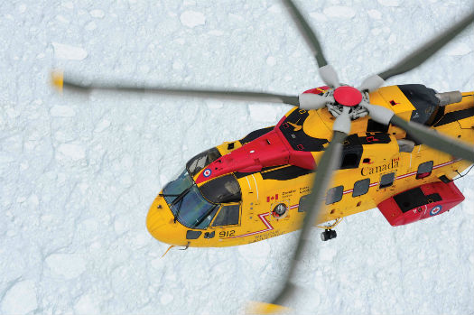
An RCAF AgustaWestland CH-149 Cormorant holds a hover during winter operations. Mike Reyno Photo
Winter brings with it a wide-ranging set of weather conditions that can affect aviation, from extreme cold, to snow, to the dreaded icing. All of these factors can at least impact helicopter operations — and at worst lead to accidents. Let’s take a look at them one at a time.
Cold temperatures are the most obvious weather element in winter. When temperatures drop below 32 F (0 C), then, of course, water can freeze, bringing with it a multitude of potential problems that will be discussed later. But when temperatures plunge below 0 F(-18 C), the cold itself can become a factor in operations. It can affect the engine and hydraulics — any system that has fluids in it.
If temperature is a major factor in flight operations in winter, the temperature profile — how the temperature changes with height — can be even more critical. We normally think of temperature decreasing with height, but this is not always the case. Inversions, where temperatures increase with height, are common in winter. This can be critical in icing situations, when pilots are looking for an escape to warmer temperatures. There are a number of situations in which inversions should be expected.
Fronts, as depicted on standard surface weather maps, are two dimensional lines that separate air masses of differing temperatures. In reality, fronts are three dimensional, with a vertically sloping frontal surface separating the air masses aloft. With the cold air being denser, it lies under the warmer air above, thus forming an inversion. The cold layer can be very shallow — only hundreds of feet thick.
Valley locations are also prone to inversions, as denser, cold air can drain down to the valley floor. If a fog layer develops, it can block the warming rays of the sun and the inversion can persist for days.
The extreme inversions often seen over land in the winter are in sharp contrast to the very steep lapse rates that can occur over the water. The air near the surface is warmed slightly by the water below. This effect lessens rapidly with height and temperatures can fall quickly as the altitude increases. Under extreme conditions, surface temperatures can be above freezing and fall to -40 F (-40 C) by 18,000 feet (5,500 m). Besides producing a very low freezing level, such lapse rates are inherently unstable, and they can support convection even during the winter.
Icing Conditions
More problematic than temperature is the presence of water in its various forms in winter. Unfortunately, water doesn’t always freeze when temperatures drop below 32 F (0 C). Such “super-cooled” water is a naturally occurring phenomenon and one that poses considerable risk to all aircraft. Although it can occur at ground level, super-cooled water is more prevalent aloft due to the decreased atmospheric pressure. The great problem with super-cooled water is that in can instantly turn from liquid to solid when it comes in contact with a surface, thus coating the surface with ice. This, of course, is the dreaded icing condition. Not only does the ice add weight and increase drag, but it also disrupts the airflow over a helicopter’s airfoil rotor blades, thus decreasing lift.
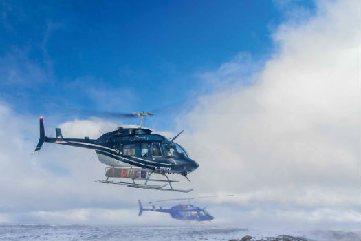
A Bell 206L-4 LongRanger operated by Great Slave Helicopters. The company flies in some of the coldest and most challenging environments in the world. Ian Wills Photo
Super-cooled water should be expected in any cloud whose temperature is below freezing. Temperatures near 15 F (-10 C) seem to be worst for icing conditions, but super-cooled water can exist down to -40 F (-40 C). If possible, helicopter pilots should avoid areas where cloud formation is likely: weather systems such as fronts and low pressures areas, mountains (especially the upwind side), and larger bodies of water (the downwind side). If caught in an icing situation, you should leave the area of clouds. Usually in winter, cloud decks are extensive and it may be easier to escape vertically rather than horizontally. You could also seek warmer temperatures above or below, but there might not be an above-freezing region.
Below the cloud base and down to the surface, we often contend with winter precipitation. The small water droplets or ice crystals in the cloud have coalesced to become large enough to fall to the ground.
Of all precipitation types, snow, which consists of ice crystals, is the worst in terms of reducing visibility. Heavy snow produces a visibility less than ¼ mile (400 meters). In “white out” conditions, visibility can drop to zero — and pilots can lose all external visual references.
Near the surface, visibility can be reduced not only by falling snow, but also by fallen snow that is picked up by the wind. This “blowing snow” can reduce visibility significantly even when no new snow is falling. The down wash from a helicopter rotor can also produce such “white out” conditions when taking off or landing, and it’s worth noting that when temperatures are well below freezing, snow tends to be drier and more prone to blowing.
With temperatures closer to freezing, large, wet snowflakes cause other problems. They will stick more to surfaces, reducing visibility through the wind shield, and often producing icing-type problems. Also, accumulated snow can break off and be ingested by the engine, causing power loss. Fatal accidents have been caused by this.
Freezing rain is comprised of liquid water droplets that fall into a shallow layer of cold air near the ground. They will freeze on contact with any surface at below freezing temperatures, and as such, ice buildup is much more of a problem. Freezing rain is common with the frontal inversions described above, usually with warm fronts but occasionally with shallow cold fronts. With a strong inversion, it is possible to have freezing rain even with surface temperatures approaching 0 F (-18 C). But freezing rain at or near the surface also indicates above freezing temperatures aloft within the clouds. (So, the solution is to go up to get out of it.)
Sleet is produced when rain falls from a warmer cloud into a somewhat thicker layer of cold air below, and freezes into ice pellets before contacting the surface. It is the least common and least troublesome of the winter precipitation types.
Clear as Fog
Fog is a great hazard to aviation anytime of the year, but winter brings variations on a typical fog. “Freezing fog” can occur with temperatures just below freezing. The fog is composed of minute super-cooled water droplets that remain suspended in the air. They can freeze on contact with any surface leaving a glaze. Usually accumulations are very light, but certainly a concern would be ice coating the windshield. “Ice fog” forms when temperatures are extremely low, often -30 F (-34 C) or lower. This time the fog is made up of tiny ice crystals. Although icing is not a threat, reductions in visibility to near zero are common. Ice fog is more common in high latitude urban areas such as Fairbanks, Alaska.
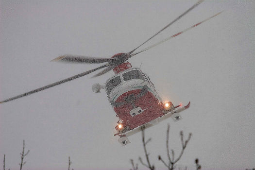
An AgustaWestland AW139 makes its way through heavy snow. This form of precipitation, which consists of ice crystals, is the worst in terms of reducing visibility. Tommaso Munforti Photo
The great winter storms are another aviation hazard. Technically called extratropical cyclones, these monster storms can bring excessive precipitation and strong winds. The Nor’easters along the Atlantic coast are a classic example. Oceanic storms can reach epic strength, rivaling their warm season tropical counterparts. Often times, these storms strengthen very quickly and are referred to as “bombs.” On Oct. 25, 1977, a vicious winter storm in the Bering Sea had a central pressure of 27.35” Hg (92.6 kPa). Winds at Adak, Alaska, gusted over 80 knots for 12 hours with a peak gust of 110 knots.
Finally, a few words about forecasting winter weather. Sophisticated computer models are excellent in producing accurate forecasts. Unfortunately, the accuracy of the forecasts produced decreases over time. Certainly major cold outbreaks and severe winter storms can be forecast at least days in advance. For precipitation, one week is probably as far out as you would want to trust a forecast. Beyond that and the timing errors would exceed a day. Temperatures are easier to forecast and outlooks covering two weeks ahead are usually good — but that’s pretty much the limit of the mathematical models today. Monthly and seasonal forecasts are a stretch. The El Nino/La Nina events do have definite effects on seasonal weather, but their occurrence and strength are difficult to forecast in advance.
Ed Brotak, Ph.D., is a retired professor of atmospheric sciences at the University of North Carolina, Asheville. His specialties include aviation weather hazards and wildfire weather.
A very fine article, however I must raise a question about Sleet / Ice Pellets, referred to herein as “least common and least troublesome of the winter precipitation types.”
My frame of reference is Sleet / Ice Pellets and the De-icing of Fixed Wing / Known Icing Approved aircraft.
I am concerned that the reader might presume Ice Pellets or Heavy Ice Pellets (weather code PL/+PL) in a Metar/ATIS/AWOS weather observation present little to no risk and that it’s perfectly safe to fly (an unprotected and non-Icing Certified helicopter) during these conditions.
In the most recent FAA Winter 2021-2022 FAA Holdover Time Guidelines, Ice Pellets are classified as a highly potent threat.
Many if not all fixed wing operators prohibit flight in Heavy Ice Pellet conditions.
De-icing during Light and Moderate Ice Pellet conditions, and conditions where Ice Pellets are mixed with other forms of Precipitation requires the use of “Allowance Times” in place of “Holdover Times.”
These Allowance Time windows, where protection is assured after de-icing has been initiated, are substantially shorter (in some cases as short as 7 minutes maximum after start of De-icing) versus the Holdover Times to be applied, for example, to Light Freezing Rain, which is upwards of 20 minutes at worst. I think we can all agree Freezing Rain is a formidable threat.
Citing the FAA Winter 2021-2022 Holdover Guidelines:
“[T]he following meteorological conditions do not have established holdover times housed in the Holdover Tables. Instead, these weather conditions have Allowance Times housed in the Allowance Times Tables that have been developed for Type III and Type IV (deicing) fluids.
1. Ice Pellets
2. Small Hail
[A]n Allowance Time unlike a Holdover Time, cannot be extended by a pre-takeoff contamination check. If the Allowance Time during active ice pellets is exceeded takeoff is prohibited and the airplane must be completely de-iced…”
FAA Winter 2021-2022 Holdover Time Guidelines
https://www.faa.gov/other_visit/aviation_industry/airline_operators/airline_safety/media/FAA_2021-22_HoldoverTables.pdf
I would also like to direct attention to this 2020 NTSB Safety Alert presenting Revised Guidance for Flight Operations in Snow
NTSB Safety Alert SA-082
Flight In Snow
https://lnkd.in/ez5XJ28q