

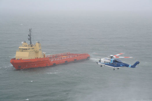

As the rain lashes down, a CHI Aviation Sikorsky S-92 approaches a ship in the Gulf of Mexico. Mike Reyno Photo
Operations along the coastline and over offshore waters represent a major component of today’s helicopter industry. From transportation to and from offshore oilrigs, to marine search-and-rescue, helicopter tourism, and general utility operations in coastal areas, all must take into account the unique weather challenges created by the coastal environment. This is the realm of “marine meteorology.”
The weather along the coast and the near offshore waters is greatly influenced by the interaction of the air and the water, with heat and moisture readily exchanged. Water has a much higher heat capacity than air, and the practical result of this is that the water temperature affects the air temperature much more than vice versa. And, of course, the water surface is a primary source of moisture in the air.
The currents just offshore have a major impact on the water temperature. The basic rule is that a current flowing poleward is warm and a current flowing equatorward is cold. Another general rule is that we find warm currents in the midlatitudes along the east coast of continents, and cold currents along the west coasts. In higher latitudes, this often reverses.
The degree to which the water affects coastal areas depends a great deal on the prevailing wind direction — whether it is onshore or offshore. In the midlatitudes, the prevailing winds are westerly. So, the west coasts tend to be more dominated by marine influences. For eastern shorelines, a less common easterly flow will bring the effects of the water inland.
So, what does all this mean to helicopter operations? Let’s look at the various weather factors that influence flying conditions.
Wind is obviously an important factor in aviation. Over the open waters and even along the coast, the wind can blow unimpeded by obstacles and largely undiminished by frictional effects.
One of the most common wind patterns along the coast, especially in the summer, involves the sea breeze. An onshore low-level flow typically develops during the late morning or early afternoon as inland areas heat up faster than the ocean surface. The low pressure created over the land literally pulls the relatively cooler marine air in. But the sea breeze circulation is more than that. About 3,000 to 5,000 feet (900 to 1,500 meters) above the ground, we have a return flow of air offshore. To complete this “circulation cell,” we have rising air over the land and sinking air over the water.
At the surface, the push of cooler air off the water generates a small-scale cold front — the “sea breeze front.” Depending on the overall wind patterns, the sea breeze front can travel tens of miles inland. Depending on how cold the water is, this front can bring a dramatic temperature fall of up to 20 F (10 C). More importantly for aviation, the sea breeze front can be accompanied by gusty winds that can quickly change direction. Another concern is that the sea breeze front may also generate convection. There may even be a low-level jet stream associated with the front, some distance above the surface, with wind speeds of 30 knots in an otherwise calm environment.
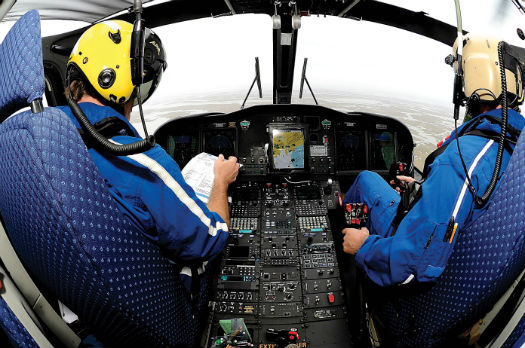
Pilots operating in coastal regions must cope with challenging wind patterns as well as the effects of abundant moisture in the air. Mike Reyno Photo
At night, when the land becomes colder than the water, the wind circulation can reverse. A land breeze can develop near the surface and blow offshore, but it typically is weaker than the sea breeze.
During the winter along the warm water coasts, an onshore flow will bring a push of mild air off the water. At times, this air can be 40 F (20 C) warmer than the air over the land. The leading edge of this warm, marine air is called the “coastal front.” And, once again, it can be associated with precipitation and gusty, shifting winds.
One particular anomaly in the wind field peculiar to coastal regions is the “coastal jet.” This is a low-level jet stream which tends to occur along the west coast of continents. It is produced in the summer by the strong temperature contrast between the cold ocean waters and the warm
land. In the Northern Hemisphere, the winds usually blow to the south. Wind speeds of 20 to 40 knots are common, and they can even exceed 50 knots. The jet core is often near 1,300 to 1,600 feet (400 to 500 meters). Coastal jets are common along the west coast of North America from California to Alaska.
Clouding the Issue
Fog is, of course, a major concern for all pilots. Even more so for helicopter pilots, who must operate at low levels. As one would expect, fog is a common problem over a water surface. When the water is colder than the air, the air is cooled from below, and with abundant moisture present, fog forms. This is very typical over cold currents, especially in the summer. This “marine fog” is particularly common off the West Coast of the U.S. and near the Grand Banks on the Atlantic side. And, with an onshore flow, this fog can reach some distance inland, although it is easily blocked by topographic features. This fog is very thick, and does not burn off during the day. It is a semi-permanent feature. At times, it can lift off the surface, but then it becomes a low stratus cloud deck. In warmer, low latitudes, marine fog can be present all year.
The cool, moist air mass found over colder ocean areas is called the “marine layer.” It is often very shallow, 1,500 to 6,500 feet (500 to 2,000 meters) thick. The top of the marine layer is marked by a very strong inversion. If a pilot flies upward through the marine layer into the continental air above, they will encounter a wind shift and a temperature increase that can approach 40 F (20 C).
Because of the abundant moisture, marine fog can also occur in the winter, even with winter storms and strong winds, presenting a dangerous combination for pilots of low visibility and high wind.
Convection is an obvious concern for pilots. With warm waters just offshore, convection can certainly be enhanced. The diurnal cycle of convection over land in the warm season is reversed over the water. Over warm water, convection often forms overnight and into the morning hours rather than during the afternoon and evening. It is dependent on the difference in temperature with height rather than just the actual temperature. With very cold air aloft in winter, marine convection is not unusual with winter storms.
Major storm systems — cyclones of various types — bring strong, turbulent winds as well as heavy precipitation with low clouds and fog, which reduce visibility. But it’s often during these storms that search-and-rescue missions must be carried out.
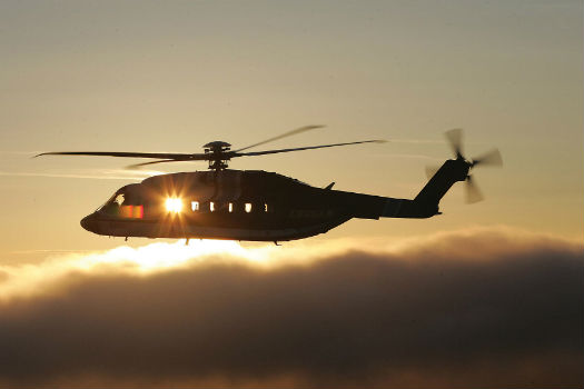
A Sikorsky S-92 flies above a layer of fog. This “marine fog” is particularly common off the West Coast of the U.S. and near the Grand Banks on the Atlantic side of the continent. Mike Reyno Photo
The strongest storms on earth form over ocean waters. Tropical cyclones, hurricanes, and typhoons develop over the warm, tropical ocean regions of the world, mainly in the late summer and fall. They often move into the midlatitudes, where they can be a major hazard to aviation — especially along the eastern side of continents following the warm currents.
In the cold season, major winter storms — extratropical cyclones — are typically associated with the warm currents that provide energy for them. Some form just offshore along eastern coastlines in the midlatitudes and then move northeastward. In higher latitudes, storms can be found in the east of ocean areas such as the Bering Sea and the North Sea. Rapidly developing storms like this are called “bombs” by meteorologists. These “winter hurricanes” can have winds gusting over 100 knots in the most extreme cases. And then there are the hybrid storms — part tropical, and part extratropical, they’re sometimes officially classified as “subtropical.” Other storms defy any classification, such as Sandy in 2012, or the famed “Perfect Storm” that developed in October 1991 just south of Nova Scotia.
Making Waves
Significant waves pose problems, particularly for marine rescue operations. Wave height is a function of wind speed and also the fetch of the wind field (how far the wind passes over the open water). Larger storms produce the biggest waves, with major winter storms commonly creating waves of 30 to 40 feet (nine to 12 meters). With the “Perfect Storm” of 1991, a buoy in the open ocean measured a wave height of 100 feet (30 meters)!
Another problem peculiar to marine operations in winter is freezing sea spray. Airborne liquid water droplets are produced by the interaction of wind and waves. With below freezing temperatures, these droplets will freeze on contact with a surface, covering it with ice. For aircraft, this would pose the same risks as more typical icing situations. Helicopters on the ground or flying at very low levels would have to contend with this phenomena.
One non-weather concern with water temperatures for marine aviation operations is survivability in the case of a rescue situation or ditching of the aircraft. Cold temperatures greatly decrease the amount of time a person can survive in the water. Even relatively warm water can result in hypothermia over time.
Marine weather is so unique and important that the U.S. National Weather Service, Environment Canada, and other national meteorological services have special marine weather groups that produce marine weather forecasts. These forecasts include winds, wave heights, and freezing spray warnings (if needed). It’s also possible to get information from private weather companies that specialize in marine forecasting.