

The modern airborne law enforcement mission can be one of the most challenging flying environments outside of military service. Its often unpredictable nature can thrust air crews into chaotic and often dangerous situations, requiring swift, accurate scene assessments, masterful coordination and intelligent problem solving.
A key element in ensuring a successful outcome in such testing circumstances is maintaining situational awareness (SA) — more specifically, awareness of the aircraft’s position relative to objects or locations on the ground. Being able to do so at night, or while working stressful, rapidly changing scenes, can be incredibly difficult, and any lapse of SA can negatively impact the ultimate outcome of a mission — and may also affect the overall safety of the flight.
However, advances in technology and the creation of innovative applications mean that today’s airborne law enforcement professionals have an increasing variety of tools that promise to help increase SA (and therefore safety), while also enhancing their capabilities and productivity.
One such tool is Churchill Navigation’s Augmented Reality Mapping System, known as ARS. In its most basic form, ARS is a moving map system. However, leveraging the latest in satellite and computer technology, ARS is anything but basic; it brings the futuristic capabilities of augmented reality and synthetic imagery to the arena of public safety aviation.
“Augmented reality combines elements of the real world with elements of a computer-generated world,” ARS developer Tom Churchill told Vertical 911. Synthetic imagery, on the other hand, “can replace the real world altogether.”
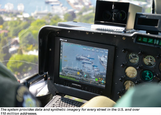
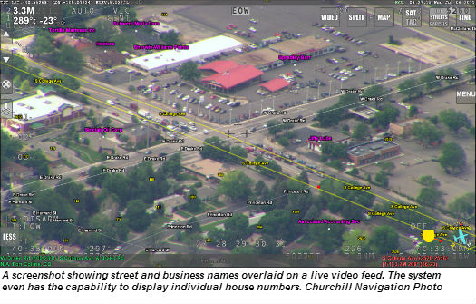
ARS utilizes comprehensive map data to present key information over a synthetic representation of a scene, or, more commonly, superimposes it over a live video feed. (It can be integrated with most of the popular gimbal electro-optical (EO) and infrared (IR) imagers, including FLIR, Wescam, Gyrocam, and Axsys.) This information can include the names of streets, businesses, parks, schools and other landmarks, and even residential property numbers — the company claims the system’s map database provides data and synthetic imagery for every street in the U.S. and over 110 million addresses. (It can also provide image and data coverage for international customers.)
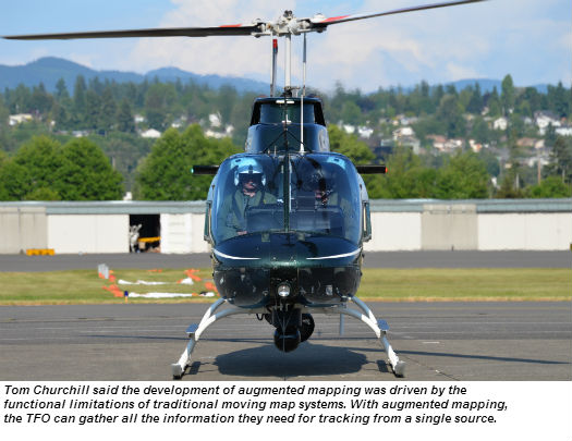
Tom Churchill said the catalyst for the development of ARS was the functional limitation of traditional moving map systems — where a tactical flight officer (TFO) following a running suspect might have to take his or her eyes off the screen to get location information from a separate source, and potentially lose the suspect in that split second.
“The TFO needed augmented reality the same way that NFL viewers benefit from the yellow first-down line superimposed by a computer system,” said Churchill. “We have always viewed technology as a means to an end — that ‘end’ is helping officers do their jobs better and look like rock stars in the air.”
In Operation
ARS can be controlled through a touchscreen monitor, a keyboard or a handheld device. To provide optimum flexibility, the operator can switch between the various imagery available and view them in isolation, or, with the touch of a button, combine them to create the augmented reality video overlay. The screen may even be split to display two different forms of imagery to meet the operator’s particular needs.
A discriminating search feature, the Fast-Search Location Look-up, allows the operator to input an address, or the name of a property owner, business, school or park. The system then performs a search, pre-filtering results based on the location of the aircraft. The operator can then select or deselect the information contained on the map overlay to meet his or her requirements. Another click of a button can slew the aircraft’s camera to lock on to the selected location, with the system providing distance to the target and estimated time en route.
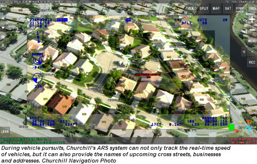
During vehicle pursuits or surveillance missions, ARS can track the real-time speed of vehicles and provide valuable information such as upcoming cross streets, business names and addresses. A tap of a finger on the touchscreen enables a handy marking feature which “tags” and records a specific location. For instance, markers can be used to tag where a fleeing suspect is seen disposing of evidence, or to mark hot-spots during an infrared search that may require additional scrutiny.
But what happens if, during a pursuit, the TFO does not see evidence get tossed but is made aware of it later on?
The tight integration of the marking feature with the built-in digital video recording capability allows him or her to rewind and review the video in-flight, while continuing to record live action. If the TFO then identifies where the evidence was tossed, he or she can “tag” the location and slew the camera back to that exact spot.
“Moreover, if you had an aircraft equipped with two gimbals, they can share a common multi-channel DVR [digital video recorder], and cross-cue,” said Churchill. “One person could be looking for the [evidence], while the other operator continues keeping an eye on the subject.”
Beyond mapping functionality, ARS also supports advanced tracking, radar sensing and survey measurement capabilities. Automatic identification system, automatic vehicle locator, LoJack, Rhotheta radar, GPS data, or any number of other special interest data sources, including dispatch data, can be directly overlaid. All of the data and video streams can be recorded to the system’s two multi-channel HD/SD video/audio recorder with a convenient output to removable SD or USB media devices. Data can also be streamed via downlink.
New applications
As augmented reality becomes more widely used, operators are finding it an extremely useful tool for applications beyond the obvious “catch the bad guys” role.
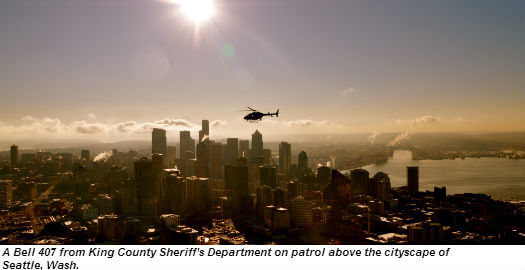
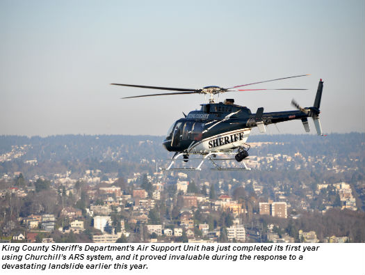
In Washington state, for example, the King County Sheriff’s Department (KCSD) Air Support Unit (ASU) is completing its first year using ARS in its two patrol helicopters, a Bell 206 B3 and a Bell 407. In March this year, when a devastating landslide wiped out the small community of Steelhead Haven near Oso, Wash., KCSD helicopters were heavily involved in the assessment of damage and search-and-rescue efforts — and the unit’s ARS played a key role in these efforts.
“Our ARS has every parcel address in the state of Washington loaded on to [a] little toaster-sized computer,” said ASU Sergeant Reid Johnson. “So as we flew over [the landslide scene] we could look on the screen, and in spite of the many feet of mud covering the entire community, the ARS [synthetic] imagery was able to show accurate representations of all the streets and the homes that once stood there.”
The data accumulated using ARS provided crucial information that aided search teams, geologists and emergency management officials. Johnson said these capabilities would be invaluable in the management of nearly every conceivable disaster scenario: earthquake, tornado, flood, wildfire or mudslide. The ability to then downlink the data only adds to ARS’ potential in aiding scene management.
The system’s marking capability also has broader applications than the individual point marking used during a pursuit — it can be used to tag multiple anchor points to delineate a specific area on the ground. In the case of a wildfire or flood, the operator can place multiple markers around the perimeter of the affected area, and ARS will use those to accurately determine its size. Follow up marking flights can collect additional data which can be utilized for computer modeling, to show the size of the affected area, the rate of spread, and the direction in which it’s moving.
KCSO ASU also uses the marking technology in Seattle’s harbor to detect and map oil spills. Flying over the harbor, ASU uses the infrared imager to locate any spills, which are marked, and the scene video recorded. The unit then notifies other agencies, including the U.S. Coast Guard, Department of Ecology and spill response teams. Johnson said such creative use of ARS increases one’s utility in the eyes of other public safety/service agencies, providing for diverse missions that are key selling points for agencies seeking to secure funding grants from local, state and federal emergency management agencies.
“You’re going to get the Office of Emergency Management involved, FEMA, [and the] Department of Transportation,” said Johnson. “They all love this kind of stuff because you’re giving them live feeds to accurately assess infrastructure, to determine things like which roads are passable.”
Churchill backs up its product with an impressive customer support package. Software updates, including annual map updates, are provided free of charge, as is on-site training (for U.S. customers), system customization and technical support via phone or email.
The airborne public safety mission will forever challenge officers with the unpredictable, but Churchill’s ARS provides operators with an unprecedented level of SA and the ability to perform a wide variety of missions in a safer and more capable manner than ever before.
Dan Megna recently retired after nearly 30 years with one of Southern California’s sheriff’s departments. His last 18 years were spent serving in the department’s aviation unit, where he logged over 8,000 hours in helicopters as a tactical officer, pilot and flight instructor.